

Ground penetrating radar (GPR) provides a subsurface imaging solution useful for a whole range of depths and targets, from finding rebar located just inches below a concrete surface to delineating bedrock 50 or even 100 feet underneath soil overburden. GPR is rapid, cost-effective, non-invasive, and non-hazardous.
Update! Logic Geophysics is using the new Sensors & Software “Ultra” GPR receiver, for maximizing the depth of imaging. Contact us to discuss using this tool on your project.
Logic Geophysics & Analytics is the GPR expert in the state of Alaska. We apply our GPR expertise for geologic mapping, road and bridge surveys, concrete imaging, utility locates, borehole clearance, ice surveys, and finding buried objects throughout Alaska and North America. Utilizing Sensors&Software industry-leading GPR equipment and advanced data processing software optimizes the results for your project. We've deployed the radar on foot, from helicopters, behind vehicles, and using snow machines, skis, sleds, snowshoes, and 4-wheelers at locations ranging from remote villages to barren tundra to the city of Anchorage and other sites across Alaska.
GPR applications:
Detecting metallic and non-metallic buried objects such as utilities (including HDPE/plastic lines), pipes, drums, underground storage tanks, and mapping landfills
Mineral exploration/ geologic mapping - depth to bedrock and paleochannel mapping
Delineating subsurface contamination such as spilled hydrocarbons and chlorinated solvents
Engineering applications including void detection, concrete imaging (rebar and PT cable), foundation investigations, and bridge corrosion detection
Railroad analysis - railway channel analyses
Mapping depth to bedrock, soil layers (stratigraphy), depth to groundwater, and ice lenses and thaw bulbs
Measuring ice thickness, snow thickness, and lake bathymetry (water depth)
Borehole GPR for mapping voids, fractures, and pilings

Red surface markings were interpreted GPR results before excavation; note the 3 matching pipes
Utility Locating
Ground penetrating radar responds to both metallic and non-metallic features, giving this tool a unique advantage for locating underground pipes and cables. Using GPR, we can simultaneously also provide estimates of target depth. We often provide on-site data processing and interpretation, which allows us to accurately mark line locations with a minimum of cost and time and to work closely with onsite drillers and excavators. When combined with GPS, we can produce geo-referenced records of interpreted locations for updating as-builts and other permanent records.

Concrete Assessment
We use GPR to evaluate concrete and locate objects within it, including locating rebar, PT cables, and embedded conduits. Very accurate location of these items is often possible, within less than an inch horizontally in most cases. Estimates of rebar corrosion can be extracted from the data response. We also commonly can estimate slab thickness and identify void locations within the concrete or below it. GPR is an excellent void detector because the contrast between the air in the void and the surrounding material is easily seen in the data.

Stratigraphic Imaging
Ground-penetrating radar can help us to understand what lies beneath the surface in a range of materials from soil and rock to ice, water, and snow. Our expertise with this tool includes imaging bedrock, water-table depths, snow and ice thickness, and soil layering such as gravel and sands. For example, we’ve used GPR to map dipping subsurface gravel and silt layers associated with river erosion and deposits in order to predict subsurface contaminant movement.

Contaminant Mapping
Ground-penetrating radar imaging can often indicate the presence of contamination plumes. Contaminant plumes may be associated with either "attenuation" (signal reduction), or "bright spots" (signal enhancement) in the processed GPR data. Using GPR in conjunction with a drilling campaign for sampling contaminant levels can maximize information and simultaneously minimize cost associated with characterizing a remediation site.
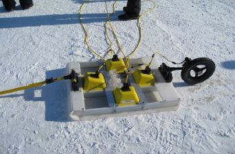
Ice and snow
GPR provides a rapid and cost-effective tool to image ice and snow thickness for ice roads and many other applications. GPR can measure snow just inches thick and measure glaciers hundreds of feet thick We've developed a dual-polarization system for measuring sea-ice thickness and demonstrated its efficacy for measuring first-year sea ice and spilled oil beneath it.
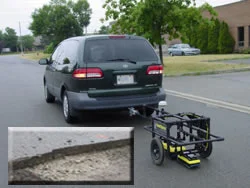
Roads and Bridges
Ground-coupled GPR systems such as Sensors&Software's "SmartChariot" can provide rapid, robust cost-effective estimates of asphalt, base course, and sub-base course thicknesses on roads and highways. Simultaneously, our expert data interpretation is often able to pinpoint anomalies associated with road-crossing utilities, conduits, and traffic loops, extracting the most value from your data. We provide bridge evaluations and corrosion reports.

Wooden underground storage tank discovered using GPR

Using a sled for grave detection on tundra and tussocks

GPR data acquisition in a steep canyon to measure depth to bedrock
Additional GPR Applications and Experience
- historical site investigations
- archaeological applications
- railway ballast testing and mapping
- identify sinkholes, mine shafts, and other voids
- placer and mineral exploration
- bridge monitoring and corrosion detection
- rock mass stability for underground mines
- bathymetry and sub-bottom profiling
- limestone quarry evaluations and rock integrity evaluation
- soil layers, stratigraphy, and characteristics
- body searches
- tunnel detection
- lake bathymetry
- detect improvised explosives (IEDs)
- intrusion monitoring
- snow management at ski resorts and ski trails
- managing soil water content for agricultural operations
- monitoring the water table
- monitoring and quantifying tree root zones
- detecting and mapping animal burrows
- inspecting wooden utility poles
- finding septic tanks, storage tanks, and other wooden and metal underground tanks
- borehole surveys